
Wetlands of the Bronx River Watershed
What is a Wetland?

A wetland is an area that is usually or periodically
inundated with water, and supports a biotic community that is at least
partly adapted to growth under wet or saturated conditions. Wetlands
vary widely because of regional and local variability in soils,
topography, hydrology, water chemistry, vegetation and human
disturbance. Wetlands can be as large as hundreds of acres or as small
as a fraction of an acre. They can have standing water much of the year
or appear dry most of the year, and they can host very different plants
and animals. As a result of this variability, wetlands can sometimes be
difficult to identify and define. Most scientists and natural resource
managers use hydrologic (source, duration, frequency and depth of
water), soil characteristics, plant communities and position in the
landscape to identify and characterize wetlands.
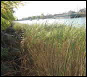
The type of wetlands found in the Bronx are estuarine (for example the salt marshes in Soundview Park), and freshwater (for example the riverine wetlands found in the Bronx River Forest and the depressional wetlands found in the Bronx Zoo).
Why are Wetlands Important?
Wetlands provide breeding, rearing, and feeding habitat for a diverse array of plants and animals, including birds, fish, amphibians, reptiles, insects and mammals.
Many species, such as dragonflies, damselflies, frogs and salamanders,
depend on wetlands to complete critical components of their life cycle.
In addition to being among the earth’s most biologically diverse and
productive ecosystems, the unique environmental conditions in wetlands
allow for biological, chemical, and physical functions that benefit
humans and the ecosystem. Wetlands play an important role in protecting
our water supply and serving as filters that trap and process sediment,
nutrients, and contaminated waters. Wetland vegetation
slows surface water flow, causing particles to drop out. The
accumulated sediment and organic matter in wetlands create a soil
matrix through which water slowly filters and re-enters the deeper
groundwater system (aquifers) or shallower groundwater that feeds
streams and rivers. Biochemical processes in wetland soils
and on plant roots help transform nutrients for plant and microbial
consumption, thus improving downstream water quality. Without these
natural zones of detention, filtration, and ground water recharge,
sediment and pollutants are more rapidly transported downstream,
damaging aquatic environments, recreational areas and drinking water
supplies.
Upslope, wetlands are critical features in the landscape
for retaining stormwater and allowing recharge into the groundwater
system. These functions are particularly critical in developed
watersheds, as is the role these wetlands play in offering scarce
habitat. Riparian wetlands, located on the banks and floodplains of
streams and rivers, slow and store floodwaters, helping to reduce
downstream flood damage and helping to reduce erosion and downstream
sedimentation that can destroy habitat and lower water quality. Tidal
marshes, including mudflats and rocky shores, along the coast also
provide a buffering and protective function for adjacent uplands while
functioning as critical nursery, rearing, and feeding habitat for fish,
crustaceans, mollusks birds, and mammals. Finally, in urban areas like
New York City, wetlands provide unique opportunities to view and
understand our ecological heritage, to study and educate our children
about the environmental issues of today, and to recreate, relax and
experience nature.
What is a Watershed?
A watershed is the area of land from which the surface water
runoff drains into the same body of water. Watersheds, also called
drainage basins, can be defined on many scales, as the land area
contributing to a small headwater stream, a tributary, or a large river.
Looking at wetlands in a watershed context is important because what
happens upstream in a watershed impacts wetlands downstream. Further,
where wetlands are located in a watershed, and how they are protected
and managed, influences the quality and quantity of water in streams,
rivers, and water bodies downstream in a watershed.
The Bronx River Watershed
The Bronx River Watershed is relatively long and narrow,
extending from Kensico Dam in Westchester County to the East River, and
drains about 56 square miles. In the Bronx, the Bronx River watershed
covers about 4,150 acres of land and is densely developed. This urban
landscape is covered with roads, buildings and parking lots (among other
impervious surfaces) which prevent rainwater from naturally being
intercepted by vegetation and infiltrating into the soil. Instead,
stormwater flows across these impervious surfaces into storm drains and
gutters, which convey the water to stormwater and sewer pipes. These
pipes transport the water to treatment plants or discharge stormwater
directly from pipes into downstream waterways. The Hunts Point water
treatment plant, located west of the Bronx River watershed, receives
stormwater captured from about 60% of the Bronx River watershed in the
Bronx. Thus, over this area, there is a disconnection between the
watershed and the river. Only during storms when the capacity of the
storm and sewer system is exceeded, is storm water released to the river
in the tidal reaches at CSOs (combined sewer overflows). As a result of
this modified hydrology, we commonly refer to sewersheds rather than watersheds in the Bronx. For more on CSOs in the NYC area click here.
Where are the Wetlands in the Bronx River Watershed?
Historically, over 27% of the lower 15.7 sq km (6 sq miles) of
the Bronx River watershed consisted of wetlands (Sanderson and Labruna
2005; More information on historical wetlands in the Bronx).
But from colonial times until the recent past, these wetlands were
drained or filled to make way for farms, roads, buildings and other
uses. In the lower section of the Bronx River Watershed, most of the
wetlands were filled and built over by the 1950's. Luckily, a
considerable amount of freshwater wetlands
are preserved along the Bronx River's riparian corridor. Upslope
depressional wetlands are rarer, but some remain in parks or as parts of
exhibits in the Bronx Zoo and New York Botanical Garden. This
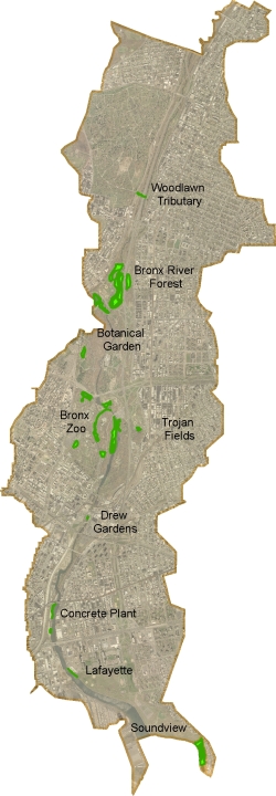
interactive map shows some of the most prominant wetlands in the Bronx
River watershed.
What are the threats to wetlands in the Bronx?
The quality of the remaining wetlands in the Bronx is
threatened by a variety of direct, indirect and cumulative impacts from
the urban watershed. These impacts include altered hydrology, invasive
exotic species, dumping of garbage, and lowered water quality from
both end-of-pipe sources and diffuse sources of pollution.
Hydrologic disturbance is a particular threat to the
riparian wetlands in the Bronx. The high volume of stormwater runoff
entering the river channel from the developed watershed creates high
energy, erosive flows that can cause bank erosion and create challenging
conditions for re-growth of native wetland plants. Frequent high flows
also carry a large amount of sediment eroded from sites in the upper
watershed and re-deposited in the channel and floodplain in the Bronx,
smothering in-stream habitat and native riparian vegetation. This
sediment also transports and creates advantageous conditions for exotic
vegetation that out-competes native plants. Rapid accumulation of
sediment on the floodplain and previous decades of channel erosion and
down-cutting can reduce the connection between the floodplain and
channel. This means that the floodplain may be only be flooded in
extreme flood events.
Water quality degradation such as increased temperatures
and reduced dissolved oxygen, also threatens riparian, estuarine and
salt marsh wetlands in the Bronx by limiting the diversity and
abundance of native vegetation, aquatic invertebrates and fish. Though
water quality has improved tremendously in the Bronx River since the
1970’s, the degree of urbanization in the Bronx, the complexity of the
infrastructure, and the history of industrial activity along the shore
means that continued vigilance to maintain and improve water quality is
critical. Water quality degradation continues from diffuse sources of
pollution such as stormwater runoff contaminated by streets, pet waste
and lawn and gardening, car washing, and flushing of harmful fluids
into storm drains. Accidental spills on streets or through broken sewage
pipes can also threaten water quality.
Even with heightened awareness about the value of wetlands,
inadvertent or intentional dumping of sediment and debris continues to
degrade riparian and tidal wetlands today. Dumping may result from
poor management and neglect or be malicious and illegal. Sediment
deposition often occurs as a result of poor enforcement of sediment and
erosion practices at construction or industrial sites. Floatable
debris get trapped in wetlands with tides and storms and can injure
wildlife, lower water quality, and impede the growth of native
vegetation.
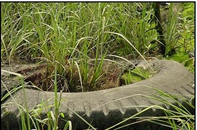
The freshwater wetlands upslope in the Bronx Zoo and Botanical
Garden are the least threatened by dumping and filling since they are
managed as part of Park grounds and exhibits. Even some of these
wetlands, however, receive sediment and surface pollutants carried by
stormwater runoff flowing over pathways and parking lots. The plants
and animals of these wetlands are also susceptible to competition from
invasive exotic vegetation such as purple loosestrife and Japanese
knotweed that readily colonize disturbed or exposed sites.

No comments:
Post a Comment