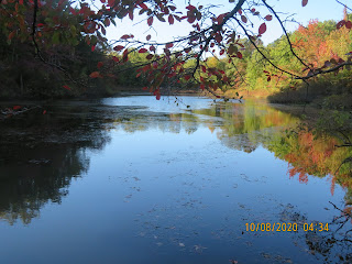
Long Pond is one of the most pristine ponds in the New York City area. Located 65 feet above sea level, it is fed completely from underground springs. Due to its elevation, the pond does not receive surface water, thus it resists pollutants that often flow into bodies of water from surface run-off. With its special level of purity, the pond is a vital habitat supporting many species of animals.
Long Pond’s history stretches back for thousands of years, beginning with the Wisconsin Ice Sheet. Twelve to fifteen thousand years ago, a huge sheet of ice blanketed the area, hundreds of feet thick. The pressure of the ice caused depressions in sections that had weak underlying rock layers. As the ice receded, these sunken areas formed wetlands such as Long Pond and Pam’s Pond. As a result, areas of stronger underlying rock were left above sea level. This topographical feature, known as “knob and kettleterrain,” can be seen throughout much of Staten Island. The extreme southern and southeastern portions of the island were not covered by the Wisconsin Ice Sheet and therefore do not exhibit this type of terrain.
Long Pond and other bodies of water in the park have been incorporated into the Bluebelt water drainage system by the New York City Department of Environmental Protection. Encompassing several parcels of state-protected wetlands on the island’s south shore, the Bluebelt system was specifically designed to provide storm water drainage for the neighboring communities. Mature beech, oak and hickory woodlands provide much of the foliage in the park, with many of the trees over sixty years old. They help to support an understory layer of spicebush (Lindera benzoin), blueberry (Vaccinium spp.) and many herbaceous plants.


No comments:
Post a Comment